Focus
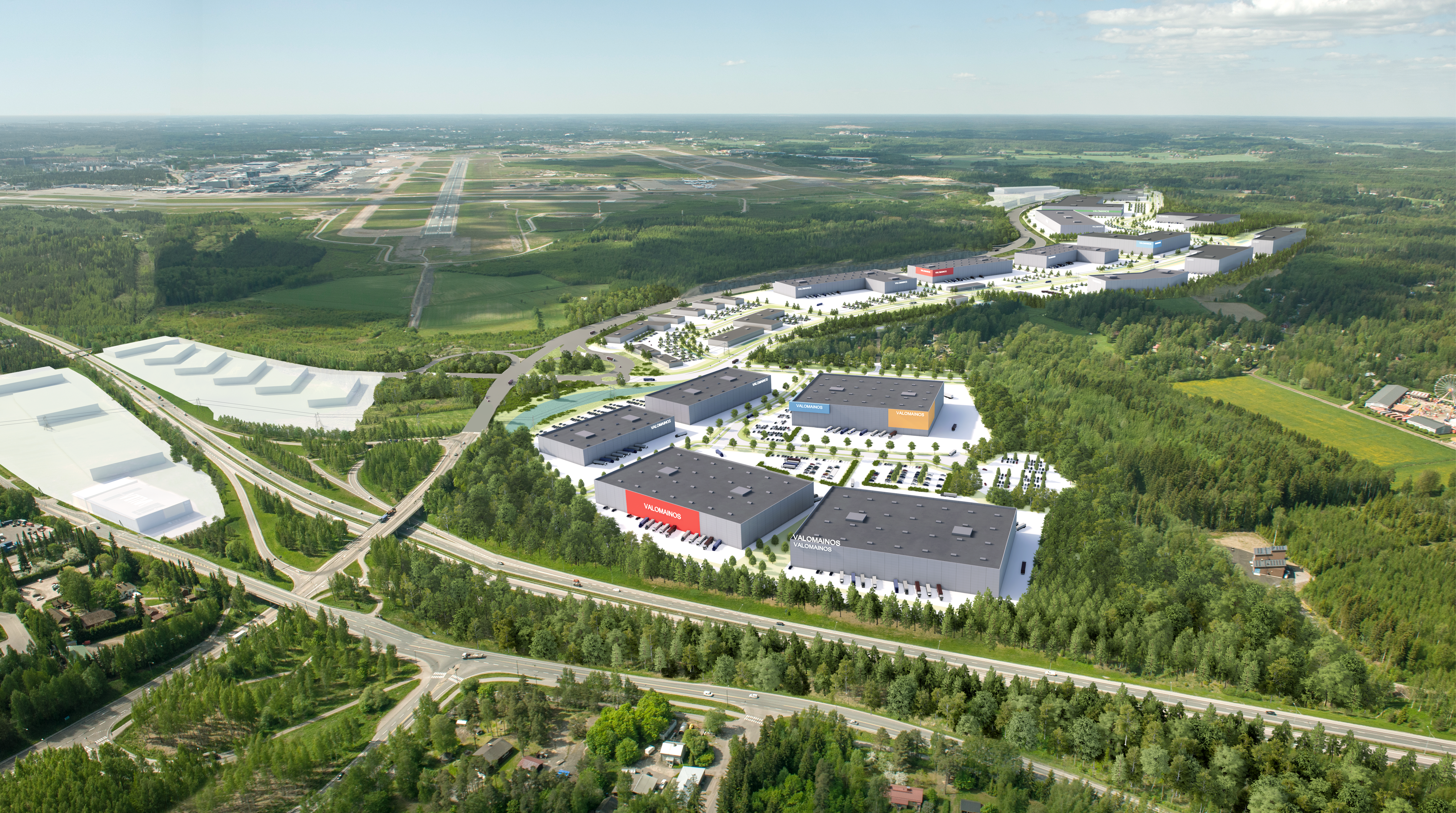
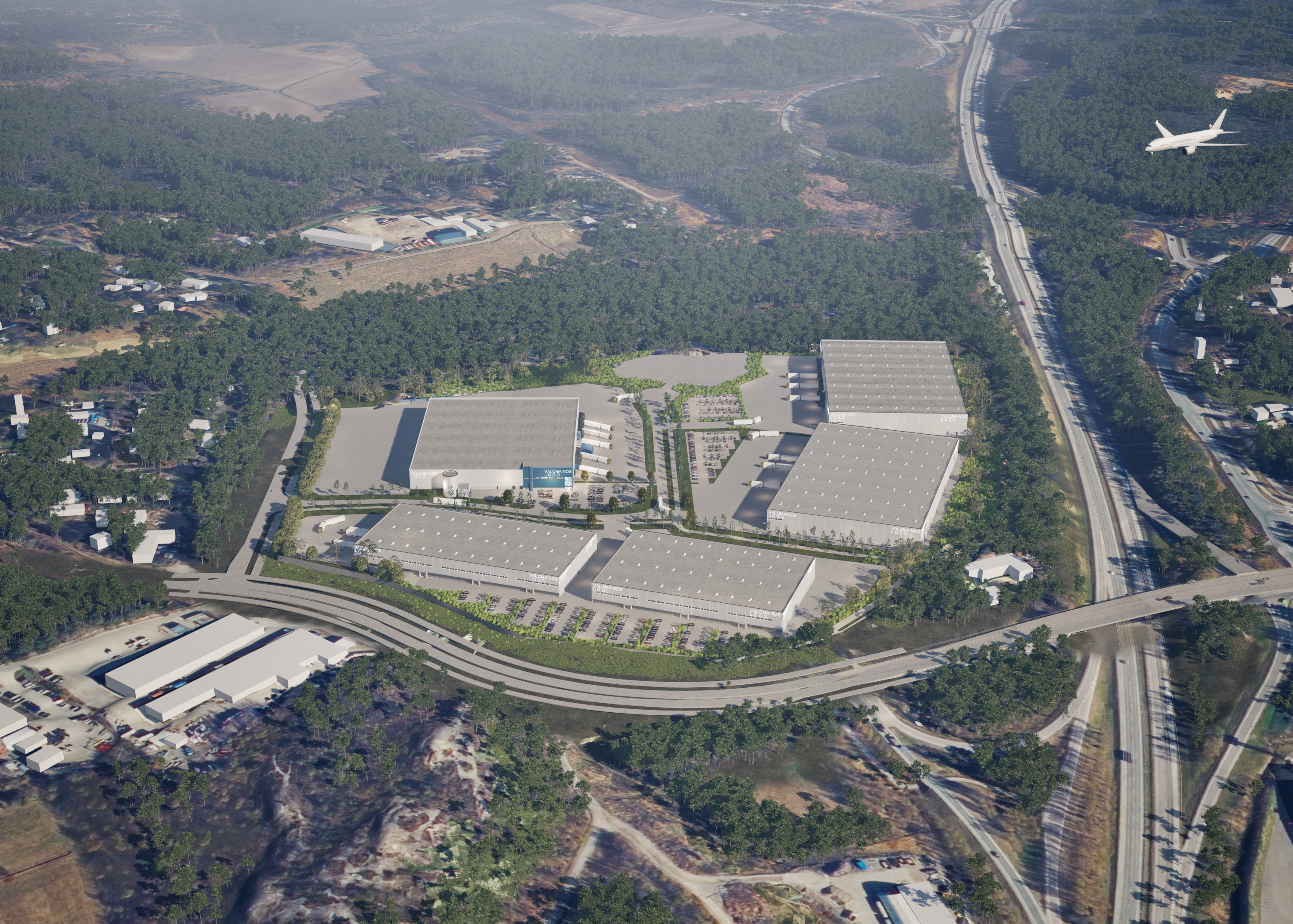
Focus is a new attractive business area planned for South Tuusula. We are developing the area for industrial and workplace plots of various sizes, but the main focus is on large building sites of over ten hectares. The total amount of construction is almost one million square metres.
Project description
Focus’s greatest strength is its logistically excellent location. The area is located on the northe edge of the capital region, next to Helsinki-Vantaa Airport, at the intersection of Tuusulanväylä (main road 45) and the future Kehä IV (road 152).
The Focus area has quick connections to major highways, ports and the nearby airport. The Kehä IV ring road, which will pass through the area in the future, is one of the planned cross-connections for logistics in Central Uusimaa. Once completed, it will create a new road connection between Hämeenlinnanväylä (Highway 3) and Tuusulanväylä (Main Road 45).
Focus Business Park(switch to another service)
Detailed plans of the area
The project area consists of several local detailed plans. The Sammonmäki III local detailed plan and amendment to the local detailed plan came into force on 16 February 2022, and the Sammonmäki IV local detailed plan and amendment to the local detailed plan on 20 August 2025. One local detailed plan is currently pending in the area: Sammontakojantie I.
Sammontakojantie I
The planning area is located in South Tuusula, between Tuusulanväylä and Myllykyläntie. The planning area is bordered to the south by the planned extension of Highway 152. The municipality’s objective is to zone the 134-hectare area for industrial, production and storage activities as well as office space. The local detailed plan will enable the implementation of a street network serving the area and the organisation of municipal engineering. The target building right for the area is over 500,000 square metres.
The draft town plan and other preparatory material were on display from 7 November to 9 December 2024. The proposed plan will be on display in early 2026.
On 26 January 2026, the Tuusula Municipal Council decided to make the Sammontakojantie I local detailed plan, the amendment to the local detailed plan and the proposal for partial repeal available for public inspection for the purpose of submitting comments and statements. The draft plan materials will be on display from 5 February to 9 March 2026.
Sammonmäki IV
The Sammonmäki IV local detailed plan and amendment to the local detailed plan came into force on 20 August 2025. Sammonmäki IV is located in a prominent location at the intersection of Tuusulanväylä and the planned Kehä IV ring road. The amendment to the local detailed plan will enable us to make more efficient use of the land in the current industrial area, implement a new street network and, at the same time, update the environmental protection regulations applicable to the area. The aim is to zone the area as a business area that allows commercial activities in addition to industrial, production and storage activities.
 (opens in a new window)
Sammonmäki III
The Sammonmäki III local detailed plan and amendment to the local detailed plan came into force on 16 February 2022, ending the long-term building ban in the area. At the same time, the transformation of the area from a residential area into a workplace area will begin. From a business perspective, the location of the area in the middle of the Focus area and next to the airport can be characterised as first-class.
The Sammonmäki area is primarily intended for smaller companies. The current building sites are approximately 2,000–2,500 square metres in size, but the indicative plot division allows for the creation of commercial plots as small as 900 square metres. Building sites can, of course, be combined to form larger ones. The entire area is privately owned, so there are no plots for sale by the municipality in the area.
Entrepreneurs should note that, due to the proximity of residential areas, activities located in the area must not cause environmental disturbance. In addition, the location of the area in a groundwater area must be taken into account carefully in both construction and operations.
Before the development of the area can really get underway, the existing municipal engineering network must be renovated and the streets widened to make them suitable for workplace functions. The schedule for the planning and implementation of municipal engineering will be specified at a later date.
Road 152 between Hämeenlinnanväylä (Highway 3) and Tuusulanväylä (Main Road 45) (Ring Road IV)
The extension of Highway 152 is a new road connection between Hämeenlinnanväylä and Tuusulanväylä to the north of the airport. The need for this road connection arises from the need for cross-connections between the main roads for new logistics centres.
The Uusimaa Centre for Economic Development, Transport and the Environment (ELY Centre) launched the preparation of a land use plan in spring 2018 in cooperation with the City of Vantaa and the Municipality of Tuusula. The land use plan has been prepared to serve the municipalities’ land use planning in particular. An environmental impact assessment (EIA) procedure was applied to the project, and the Uusimaa ELY Centre’s Y-responsibility area issued a reasoned conclusion in August 2020. The actual land use plan was completed in December 2020.
The project is managed by the Transport and Infrastructure Division of the Uusimaa Centre for Economic Development, Transport and the Environment.
Contact information
Project Manager
Petteri Puputti
+358 40 314 3515
petteri.puputti@tuusula.fi
Land use planner
aamu.kurjenpuu@tuusula.fi
Municipality
of Tuusula
PO Box 60 (Moukarinkuja 4C)
04301 Tuusula
Finland
+358 9 87181
This content has been translated using AI